Port Blair Fm
Type Locality and Naming
Named after Port Blair area. The term ‘Port Blair Formation’ was introduced by Oldham (1885) for the sandstones and shales of Port Blair area. His ‘Port Blair Series’ included Port Blair sandstones and Baratang Shales. Anand (1960) used the term ‘Port Blair Formation’ only for the upper sandy sequence of Oldham’s ‘Port Blair Series’ and this usage has been followed by subsequent workers (Pandey et al., 1993) (Source: Pandey and Dave, 1998).
[Original Publication: Oldham, R.D., 1885. Notes on the Geology of the Andaman Islands, Rec. Geol. Survey of India, Vol. 18, pt 3, pp. 135-145.].
Holostratotype is Corbyn’s Cove-South Point traverse near Port Blair town, South Andaman (between Gymkhana Ground to near Corbyn’s Cove).
Lithology and Thickness
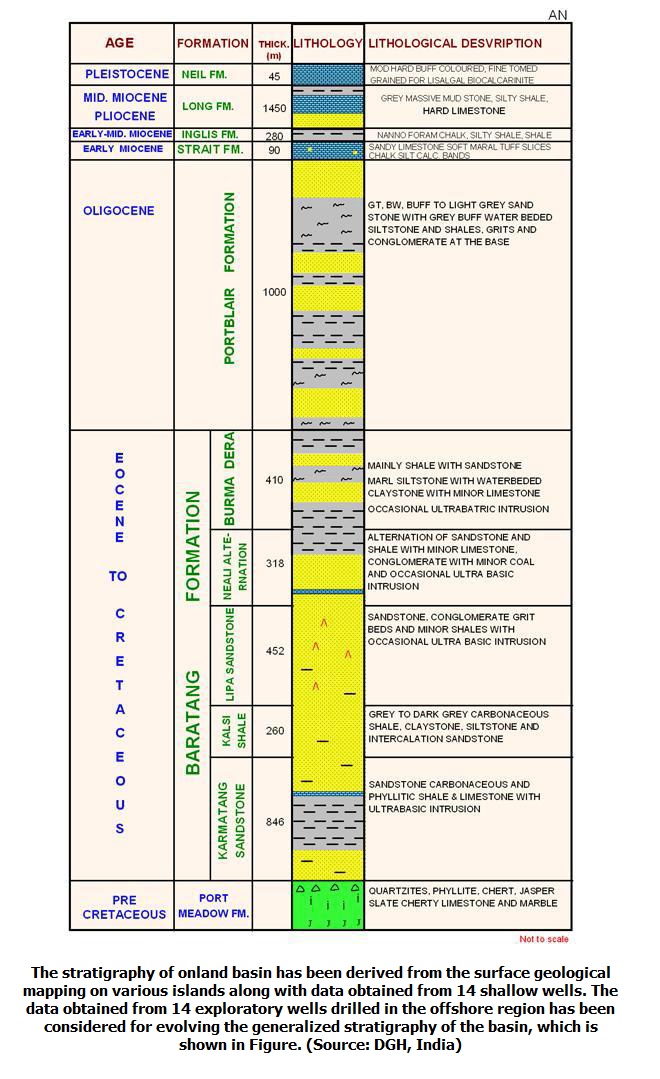
Flysch (Sandstone-Claystone). In the holostratotype area of Port Blair, the formation consists of alternating sequence of sandstone and shales. In the basal part, the sequence comprises of conglomerate and grit beds. In hypostratotype area the formation overlies the Burma Dera Member marked by a conglomerate. The maximum thick of Port Blair Formation was estimated to be >1100 m by Chandra et al., 1961.
[Figure 1: Generalized Subsurface Stratigraphy of Andaman-Nicobar Basin (from dghindia.gov.in)]
Relationships and Distribution
Lower contact
Unconformable on the Baratang Fm
Upper contact
Unconformably overlain by the Strait Fm as observed on Strait Island
Regional extent
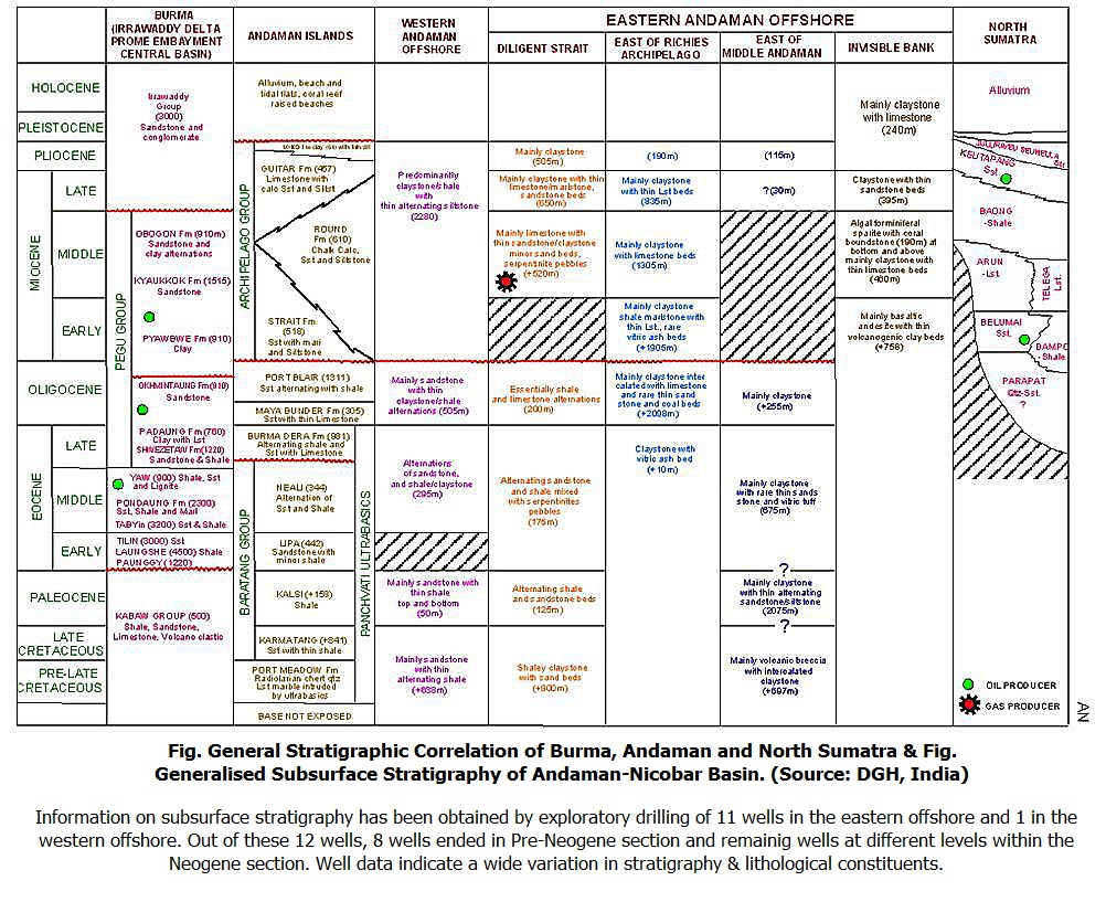
[Figure 1: General Stratigraphic Correlation of Burma, Andaman and North Sumatra (from dghindia.gov.in)]
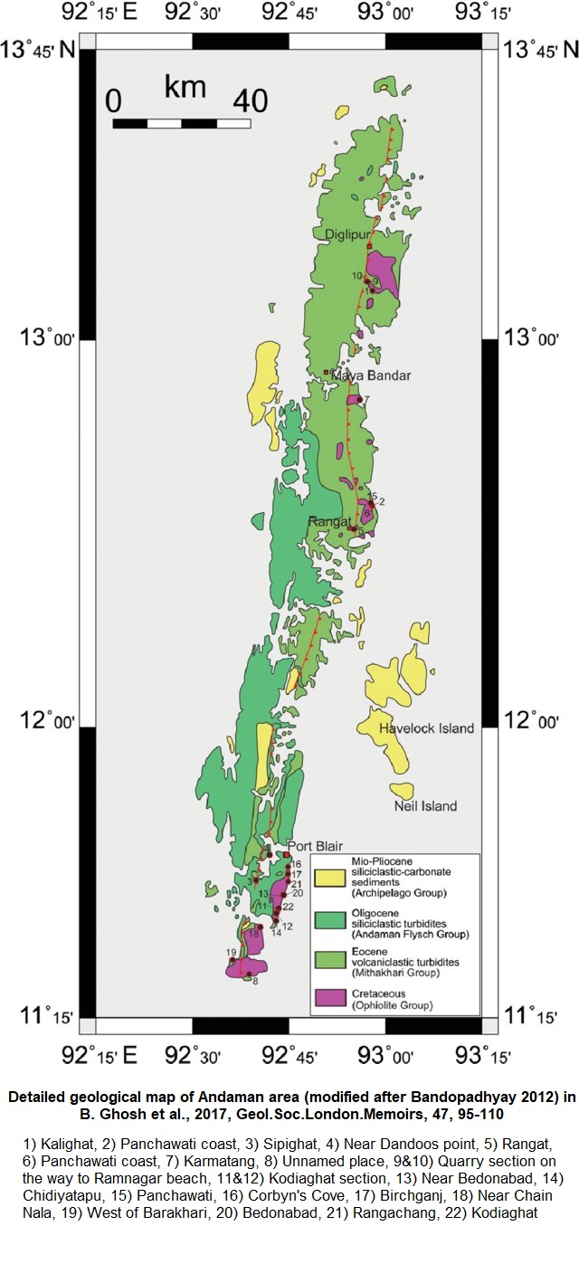
[Figure 2: Detailed geological map of Andaman area (modified after Bandopadhyay 2012) showing locations mentioned in numbers in B. Ghosh et al., 2017, Geo.Soc.London.Memoirs, 47, 95-110)]
GeoJSON
Fossils
Chandra et al. (1961) recorded some broken lamellibranch shells from conglomerates and a few Dicotyledon leaf impressions. Tipper (1911) described Nummulites atacicus from this unit. N. miarritzensis and Assilina granulosa was also reported from sandstones of South Andaman. Gee reported A. granulosa from calcareous sandstone in northern part of Middle Andaman. Besides, foraminifera including Cibicides sp., Rotalia sp. Textularia sp and Globigerina sp. etc have also been recorded from this formation.
The reported Nummulitic assemblage of Lower Eocene is apparently reworked.
Age
Depositional setting
Deposition by turbidity currents. Lack of fossil markers exact paleobathymetry is not inferred.
Additional Information


